Gallery


Possibilities of use of GDV method in the short term prediction of Earthquakes
Roman Yusubov, LLC Biotechprogress
1. Relevance of the question. Relatively positive results in long-term and medium-term prediction of the earthquakes. Traditional approach in the short-term prediction of the earthquakes nowadays does not have any effective solutions. Necessity of the short-term prediction of the seismic occurrence.
2. Involvement of new methods to the research. GDV technology for study of ecological systems. Methodological basis of the study of influence of environmental factors.
3. Main principles of recording of the gas discharge images and their subsequent computer processing. Recording of the dynamics of environmental changes using a measuring electrode (antenna).
4. The pilot project of “Biotechprogress” company: environmental study on the territory of a seismic dangerous zone in the Republic of Moldova, Taraklia district. The study was carried out on the reinforced model of “GDV Compact” equipped with a measuring electrode (antenna), in the period of December, 2014 – November, 2016, in the twenty-and-four-hour regime, interval of the recording 60 sec.
5. Continuation of the research. Development of the hardware and software complex with distant operating and receiving of data from several GDV devices, placed in different geographical points.
An earthquake is the shaking of the surface of the Earth. The most dangerous of them arise due to tectonic displacements and ruptures in the earth's crust or the upper part of the Earth's mantle. Fluctuations from them in the form of elastic seismic waves are transmitted over huge distances; near the sources of earthquakes they cause destruction of buildings and death of people. Earthquakes and related phenomena are studied by the science - seismology, which conducts research in the following main areas:
1. Study of the nature of earthquakes, in other words, investigation of why, how and where they occur.
2. Application of knowledge about earthquakes for protection against them by forecasting possible seismic impacts possible in one or another place, in order to build defensive constructions and buildings resistant to their impact.
3. Study of the structure of the earth's interior and exploration of mineral fields using seismic waves from earthquakes and artificial seismic sources.
Nowadays the range of devices used for recording of terrestrial oscillations is quite large. You can get information about just occurred earthquake right after the moment it happened due to its registration on a special web-site. During the year more than a million different earthquakes are recorded, at the same time, the strength of earth vibrations of most of them is not dangerous for people’s lives.
As a rule most of the earthquakes become known due to the damage they cause. Not only underground fluctuations themselves are dangerous. They usually cause many other phenomena, such as tsunamis, emissions of lava; volcanic gas and ash to the surface of the earth. Unfortunately, their fame is higher the more human sacrifices they take. This occurs most often in zones of increased seismic activity and these zones are known to mankind. The use of equipment that can signal the forthcoming earthquake in advance can help to avoid human victims, as well as possible techno genic accidents.
It was experimentally observed that generation of infrasonic oscillations in the range up to 6 Hz, leading to a change in the electro-physical characteristics of the air above the earthquake region, takes place over the earthquake focus a few hours before its beginning. The presence of these infrasonic waves, causing a state of discomfort in animals and birds, has long been used to predict future earthquakes.
It was stated that before the eruption the characteristics of the gas discharge glow of the air above the zone of the future earthquake changes. Presumably the electromagnetic radiation caused by the processes occurring inside the earth before the earth's oscillations, fixed by the sensor, is amplified by a gas discharge, which enables us to visualize this electromagnetic radiation.
On the basis of 2015-2016 study “Biotechprogress” company has developed a hardware and software complex “GDV Geo”. Devices were subjected to stringent requirements for increased reliability and resistance to climate change.
The equipment was tested in the field in winter and spring, and during this study were found interesting technical solutions.
The complex represents itself a group of GDV devices with the built in computer blocks. It is placed on the territory of a seismic active point, records environmental changes and in the on-line regime transmits data onto the remote server.
“Biotechprogress” company has implemented the following technical specifications:
1. Work of the complex from the network or from the battery;
2. Possibility of regular airing of the space under the cover of the GDV device;
3. Inside the GDV Compact was built in a computer block, which enables independent work of the complex;
4. Use of “Sputnik” sensor;
5. On the connector panel there was placed a complex of slots for memory card, onto which .bmp files of GDV images are stored. They are accessible to operator, including the one, working remotely via the web-site.
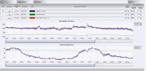
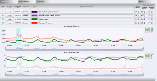
6. The implementation of the program to collect data received from the sensor - "Sputnik", working in combination with the GDV complex, in on-line mode of data transmission. The program consists of two components: 1. Controller for data collection from the GDV device and their sending to the server. 2. Server - collects and stores data from several remote controllers, generates web-interface pages for remotely-connected users, sends out alerts (SMS and E-mail). The user works through the web interface that is organized in the form of several switched pages: "graphs" - information from sensors, "users" - setting of notification addresses (SMS and E-mail) and user access level, "settings" - setting up the survey process and on-line mode of information flow. The program provides access - "Unloading" to the database of basic GDV parameters.
7. Work of the computer represents itself reception of .bmp images, parametric processing of the received data, calculation of area and intensity, the transmission to the server once a minute of a message in txt format, which contains the following information: device number, location, area and intensity parameters.
8. The server analyzes increase or decrease of the data. When the parameters are changed more than the number specified by the operator, the server issues an "alarm" message. Also, the server maintains an on-line graph of all calculated parameters, while saving the results.
9. Data collection from several GDV devices located at different points, for analysis, per one server.
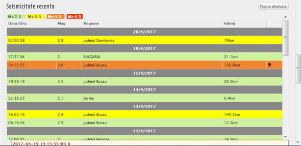
During for six months there were tested 3 new complexes “GDV GEO”, which were located in Pomyalovo village, Volkhovskiy region, Russia; Chisinau, Moldova; Musait village, Tarakliya district, Moldova. All the devices were tested in the twenty-and-four-hour regime, interval of recording 60 sec. At the same time, a weather archive was created: temperature, pressure, precipitation. Data on the seismic activity of the region were taken from the archive of seismic observations of the site of the National Institute of Physics of the Earth (Romania)
http://www.infp.ro/.
Only earthquakes with fluctuations above 2.8 points and a source up to 180 km from the equipment installation zone were considered.
To identify the most stable signal of environmental changes, the space for the equipment was selected consistently. Thus was noted the inefficiency of using the equipment placed on the balcony of a multi-store house, device installed in Chisinau.
In this case, we get a stable graph without any changes, which, most likely, indicates the loss of sensor sensitivity. On the chart below, you can observe the decrease in area and intensity values, starting at approximately 10 am. That, however, was the result of a change in the temperature and humidity of the air inside the balcony. The reason for this was the switched on heater and jeans hung for drying.

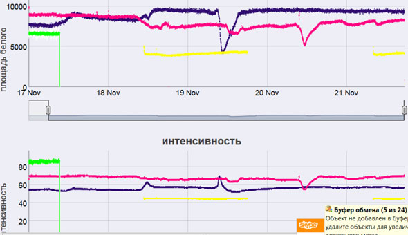
Inefficient use of equipment also occurs when the equipment and antenna are in direct contact with the ground. In this case, we get a graph with numerous changes, which indicate that antenna is too sensitive (Fig. 1 zone from 01 to 05 April from 12 o'clock).

Fig. 1 The graph (blue, location - Musait) corresponds to the grounding of the sensor "Sputnik" directly into the soil.
At the moment it is established that the optimal position for the complex is to place it in an open type station with protection against precipitation at a distance of 0.5-1.5 meters from the ground surface. It is also necessary to take into account the orientation relative to the sun. If we want to exclude the registration of sunlight on the sensor, then it should be placed in the shady side. (Fig. 3)

Fig.2 The graph (red, place of installation Pomyalovo) clearly shows the time of direct hit of the sun onto the sensor.
Other changes in the parameters were also recorded, probably related to regular weather events: solar activity, humidity, precipitation, sudden temperature changes, etc.
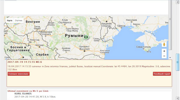
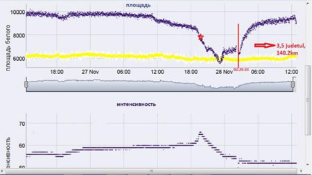
Fig.3 Examples of signal changes before the earthquake.
А)19,04,17 at 14:15: 3.6 points on the Richter scale, 135 km, Buzau
B)19,11,16 at 14:30: 4.4 points on the Richter scale, 143 km, Vrancha platform.
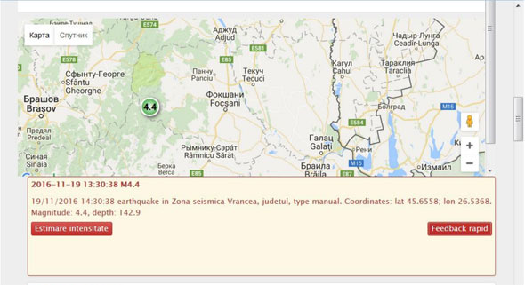
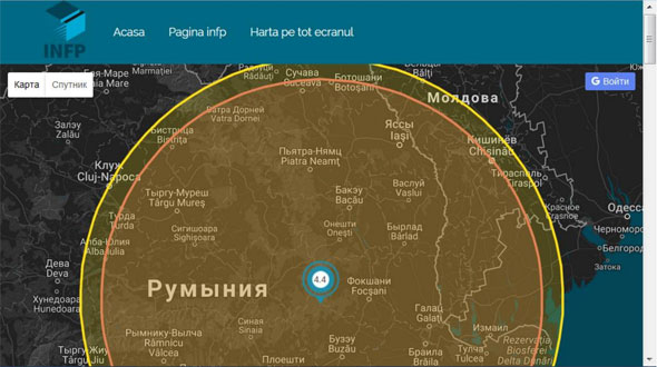
B)19,11,16 at 14:30: 4.4 points on the Richter scale, 143 km, Vrancha platform

В)19,04,17 at 14:15: 3.6 points on the Richter scale, 135 km., Buzau. Quiet period, March, 1-5
С)27,11,16 в 02,25: 3,5 points on the Richter scale, 140,2 km, Vrancha platform
The company "Biotechprogress" received the certificate for the software product, which was named as "GDV GEO". We also filed the application to “Rospatent”, (FIPS - Federal Institute of Industrial Property), (No. 2016148522/28 (077940) dated 12.12.16) for obtaining a patent for the method and device for predicting of earthquakes. In connection with the registration of an application with “Rospatent” of the Russian Federation, the company has priority on obtaining an international patent.
The reliability of the data obtained with the help of the hardware and software complex “GDV GEO” is 60-65%. The work on the increase in the percentage of data reliability continues.
- Login to post comments
User login
Last articles


